 Si presume che la costruzione del sentiero sia databile al IX secolo. Il sentiero si apre ad un’altitudine di 530 m con un andamento lento, nord-sud per 50 metri; giungendo all’ingresso di una cavità conosciuta come “Il Grottone”. In origine il percorso fu costruito per congiungere il Pianello con la frazione di Capodigiano. Oltre a questa funzione, il percorso permetteva l’approvvigionamento dell’antico borgo. La strada scende fino al torrente Rescio con piani a gradoni calcarei, talvolta scavati nella roccia. Lungo il percorso ci sono muri a secco e resti di mulini ad acqua edificati a inizio ‘800.
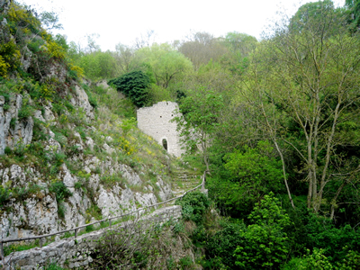
 This old footpath was probably built in the 9th century to connect the “Pianello” with the suburb of Capodigiano. It was also used to transport materials, food and resources that people, were living in Pianello, needed. At the top the altitude is about 530 metres, and it develops in a winding line and after 50 metres from the start there is a cave known as “Grottone”. The path descends to the stream Rescio by means of limestone stairs, sometimes diged in the rock. Along the path are still visible dry stone walls and ruins of watermills built in the 9th century.